Formal Consultation – MMO management of fishing activity impacts in marine protected areas – Stage 3
Overview

Guidance (Please read before completing the survey)
Before providing any responses, the documentation below is available to familiarise yourself with the Stage 3 formal consultation and the steps involved in the creation of the site assessments. Referencing specific pages and paragraphs in your response will help us fully understand your comments and give them the greatest value.
There are several options, you can provide;
- a general response under the ‘General comments’ section; or
- a general response to a specific region under the relevant ‘region – regional comments’ section; or
- a response to a specific site.
You do not need to provide a response on every section, it is possible to respond only to the points of interest.
We have provided below, recommended questions you may wish to address in your response:
- Do you have any additional information about the location, condition, or sensitivity of the designated features?
- Do you have information on the type, location, frequency, or intensity of fishing activity within the MPAs?
- Do you agree or disagree with the proposed management measures? Do you have any suggestions for other management measures?
- How would the proposed management measures affect you? Or those you represent?
- What impacts, if any, do you anticipate the proposed management measures will have on UK fishing vessels, operators, or supply chains?
- What impacts, if any, do you anticipate the proposed management measures will have on non-UK fishing vessels, operators, or supply chains (including those from the EU)?
-
What other impacts could the proposed management measures have? For example, on fishers, the wider fishing community, coastal communities, employment, upstream and downstream supply chains, people with protected characteristics under the Equality Act 2010, fish stocks, the marine environment.
If you have evidence to support your response, please provide this to better enable us to consider any comments.
You can save your response as you go so that you can return to it later. Or you could write up your response in a separate document and copy and paste your response into the survey.
All documents highlighted in bold below can be accessed in the related documents section.
Stage 3 interactive maps
To support the formal consultation on management measures for Stage 3 marine protected areas (MPAs), MMO have developed interactive maps called WebApps.
We have also produced a WebApp guidance document on how to access and make the most of each WebApp, to help users provide informed consultation responses.
Background
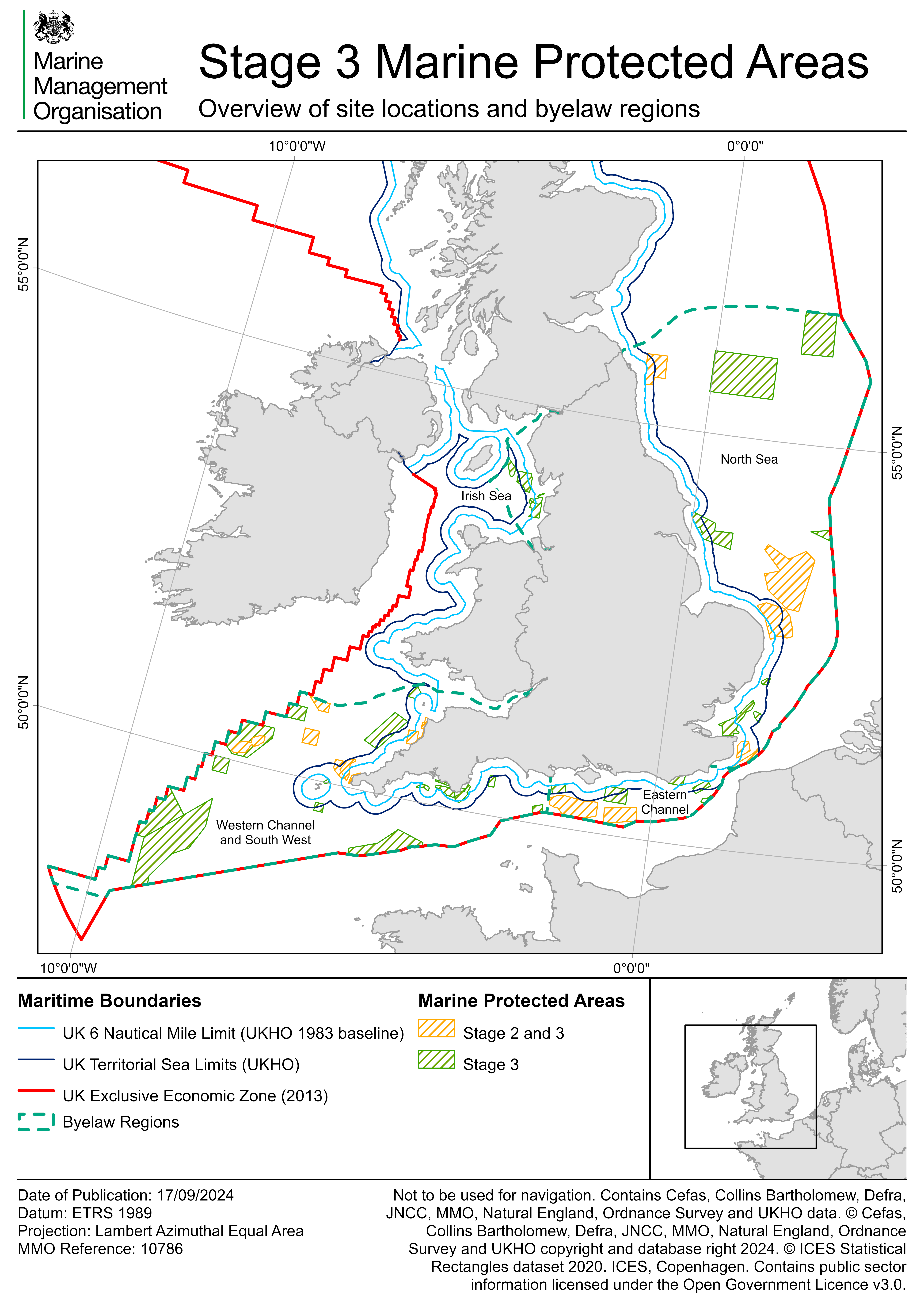
The Marine Management Organisation (MMO) is seeking views on assessments of the impacts of fishing on 43 marine protected areas (MPAs), and proposed management measures for 42 MPAs, as well as a de minimis assessment (DMA), which captures the rational for, and the predicted costs and benefits of, the proposed byelaw. This will support our analysis and subsequent management of the impacts of fishing activities on important seabed features within 43 MPAs offshore of 6 nm. This consultation will run from 9 June to 29 September 2025. The Stage 3 consultation document summarises the consultation material. A Stage 3 site assessment methodology document has been prepared to outline the process involved in the development of the Stage 3 site assessments.
This consultation is part of Stage 3 of the MMO project to manage fishing in all English offshore MPAs. Stage 3 focusses on managing the impacts of fishing on all seabed features in MPAs not already protected by existing MMO byelaws. Stage 3 MPAs cover an area of almost 31,000 km2.
This latest consultation follows a call for evidence on draft gear-feature interactions documents which ran from 17 January to 28 March 2023. Following consideration of responses, these documents, along with a call for evidence decision document, have now been finalised and are available to view in the related documents section below.
Four byelaws are being proposed;
- North Sea;
- Eastern Channel;
- Western Channel and South west; and
- Irish Sea.
They cover 43 Stage 3 sites and also incorporate existing Stage 1 and 2 measures for consistency and ease of compliance. These proposals will therefore impact 47 sites in total.
The survey has been structured according to the four proposed regional byelaws and their associated MPAs.

The table below highlights which MPAs fall within each of the byelaw regions. Please see the separate site sections of the survey to access the MPA fisheries assessments for individual sites.
| North Sea | Eastern Channel | Western Channel and South West | Irish Sea |
|---|---|---|---|
| Farnes East | Bassurelle Sandbank | West of Wight Barfleur | Fylde |
| Swallow Sand | Inner Bank | East of Start Point | Shell Flat and Lune Deep |
| Fulmar | Beachy Head East | Skerries Bank and Surrounds | West of Walney |
| Holderness Offshore | Offshore Brighton | Start Point to Plymouth Sound & Eddystone | West of Copeland |
| Markhams Triangle | Offshore Overfalls | Western Channel | |
| North Norfolk Sandbanks and Saturn Reef | Wight-Barfleur Reef | South-West Deeps (East) | |
| Haisborough Hammond and Winterton | Albert Field | South-West Deeps (West) | |
| Orford Inshore | South of the Isles of Scilly | ||
| Margate and Long Sands | Bristows to the Stones | ||
| Kentish Knock East | North-West of Jones Bank | ||
| Goodwin Sands | Haig Fras | ||
| Foreland | Greater Haig Fras | ||
| North-East of Haig Fras | |||
| South of Celtic Deep | |||
| East of Haig Fras | |||
| Cape Bank | |||
| Lands End and Cape Bank | |||
| South-West Approaches to Bristol Channel | |||
| Hartland Point to Tintagel | |||
| North West of Lundy |
All documents highlighted in bold above and other relevant documets can be viewed in the related documents section.
If you find that you are unable to access any links to conservation advice from the Statutory Nature Conservation Bodies in the Stage 3 documents, please go to Natural England’s designated sites search and search for the MPA you are interested in, or go to JNCC’s offshore MPA homepage and select the site that you are interested in.
UPDATE 20 June 2025: The Irish Sea Marine Protected Areas Fishing Gear Byelaw 2024 draft document has been updated with corrections made to map coordinates.
UPDATE 22 July 2025: In response to requests from stakeholders the decision has been made to extend the consultation period by 4 weeks, meaning the consultation will now close on 29 September 2025 (Originally 1 September 2025). This will allow more time for you to consider the consultation documentation and provide detailed responses to our proposals.
UPDATE 5 August 2025: The shapefiles for the proposed and current MPA management areas discussed in the Stage 3 formal consultation are now available to download and review. Please see the 'Related' content below.
UPDATE 19 September 2025: We have identified an error in the The Western Channel and South West Marine Protected Areas Fishing Gear Byelaw 2024. This has now been updated with correct coordinates for the specified areas for Southwest Deeps (East) MCZ and the Southwest Deeps (West) MCZ.
What happens next
MMO will review the information received during this formal consultation and update and finalise our Stage 3 site assessments, byelaws and impact assessment. If we conclude that management measures are required, MMO will make the byelaws and submit them to the Secretary of State for confirmation.
Audiences
- All Marine Users
Interests
- Biodiversity
- Common Fisheries Policy
- Conservation
- Consultation
- Consultations
- DEFRA Policy
- Fish stocks
- Marine
- Marine Conservation
- Marine Conservation Zones
- Marine fisheries
- Marine licensing
- Natural environment
- Policy and Delivery
- Sea angling
- Shellfish


Share
Share on Twitter Share on Facebook